Cotswold Edge Walks |
A selection of walks climbing the scarp

Devils Chimney
3 miles
This truly uplifting walk reaches a crescendo at the mysterious Devils Chimney. No one really knows how this feature was made but there is no doubt it stands in a beautiful position looking out over the Severn Valley. A short walk but many view point opportunities.
| OS Grid Ref | SO 952 189 |
| GPS Latitude | 51.868363 |
| GPS Longitude | -2.074558 |
| Post Code | GL53 9QQ |

Devils Chimney
Park in Daisybank car park or just a few yards further along the road in a layby.
(From the Daisybank car park walk right on the road until you reach the layby).
 Opposite the layby you will see a footpath sign and a metal style.
Cross the style and head down the hill.
As view a view opens up towards Cheltenham and the edge of the Cotswolds open up the path forks in two.Take the right hand path.
Opposite the layby you will see a footpath sign and a metal style.
Cross the style and head down the hill.
As view a view opens up towards Cheltenham and the edge of the Cotswolds open up the path forks in two.Take the right hand path.
 In a few yards you join another footpath.Turn left here.
You are now on the Gustav Holst Way.
In a few yards you join another footpath.Turn left here.
You are now on the Gustav Holst Way.
 Head downhill along the path lined with trees and shrubs.
 Ahead, you will see views of Cleeve Hill in the distance. As you continue down in to trees the path splits in two.Take the path on the left through the gate.
The footpath eventually reaches the first buildings on the edge of Cheltenham.
Ahead, you will see views of Cleeve Hill in the distance. As you continue down in to trees the path splits in two.Take the path on the left through the gate.
The footpath eventually reaches the first buildings on the edge of Cheltenham.
 Turn right on a path at the rear of the first building and soon you will pass through a kissing gate and over a board walk.
You will see views of Hartley Hill to your right.
The next footpath sign points to the right and takes you into a courtyard.
Turn right on a path at the rear of the first building and soon you will pass through a kissing gate and over a board walk.
You will see views of Hartley Hill to your right.
The next footpath sign points to the right and takes you into a courtyard.
 Follow the path through the courtyard and head along the road past some large pine trees.
 At the end of the road turn right and follow this footpath which now begins your climb uphill. Lilley Brook golf course will appear to your left.
After a few hundred yards you will start to climb properly. This section is hard work but is good excercise and you will be rewarded!
At the end of the road turn right and follow this footpath which now begins your climb uphill. Lilley Brook golf course will appear to your left.
After a few hundred yards you will start to climb properly. This section is hard work but is good excercise and you will be rewarded!
 3/4 of the way up the hill, pass through a gate and continue to climb, bearing left.
The path is quite uneven as hundreds of years of wear and tear have taken their toll.
3/4 of the way up the hill, pass through a gate and continue to climb, bearing left.
The path is quite uneven as hundreds of years of wear and tear have taken their toll.
 As the path levels, keep left and eventually you will be on a wide, flat and well made path.
 Pass through a gate and continue forward on the wide path until you see a Cotswold Way footpath sign on the left.

 Pass through the gate on the right and head uphill. The path splits here. Take either route, they will soon join.
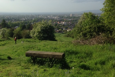
As you climb, tantalising views in the far distance appear for a moment.
 Continue through the next gate, climbing with a dry stone wall to your left.
Shortly a drop appears on your right and fantastic views of Cheltenham, the Cotswold edge, Severn Valley and the Malverns
(in the far distance) are to be seen.
Continue through the next gate, climbing with a dry stone wall to your left.
Shortly a drop appears on your right and fantastic views of Cheltenham, the Cotswold edge, Severn Valley and the Malverns
(in the far distance) are to be seen.
 After passing a couple of benches (if you can resist the urge to sit and soak in the wonderful view)
continue for about 1/4 mile until the path forks left (just after three benches on the left).
After passing a couple of benches (if you can resist the urge to sit and soak in the wonderful view)
continue for about 1/4 mile until the path forks left (just after three benches on the left).
 Follow the left fork, pass through a gate and go straight on through the trees.
Follow the "Cotswold Way" and "Crickley Hill Walks" marker posts.
You are now on Leckhampton Hill.
Follow the left fork, pass through a gate and go straight on through the trees.
Follow the "Cotswold Way" and "Crickley Hill Walks" marker posts.
You are now on Leckhampton Hill.
 Look out for an information point on your left explaining about 2000 years of settlement.
From here continue on the path to a concrete triangulation post (trig point). Here you will be 293 meters (961 feet) above sea level.
Look out for an information point on your left explaining about 2000 years of settlement.
From here continue on the path to a concrete triangulation post (trig point). Here you will be 293 meters (961 feet) above sea level.
 Keeping the trees and shrubs to your right head towards another post (similar to the trig point).
When you get there you will find it is a topograph showing you what you can see from this vantage point.
On a clear day you will see across to the Black Mountains in Wales.
Keeping the trees and shrubs to your right head towards another post (similar to the trig point).
When you get there you will find it is a topograph showing you what you can see from this vantage point.
On a clear day you will see across to the Black Mountains in Wales.
 Turn left along the top of an old stone quarry. Do not stray too close to the edge.
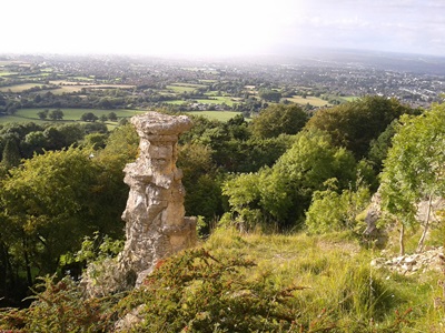
 At a footpath sign turn right towards Devils Chimney. Soon you will see the 'chimney' below you on the left, proudly standing before a viewing area.
No one really knows how this feature was made but there is no
doubt it stands in a beautiful position looking out over the Severn Valley.
At a footpath sign turn right towards Devils Chimney. Soon you will see the 'chimney' below you on the left, proudly standing before a viewing area.
No one really knows how this feature was made but there is no
doubt it stands in a beautiful position looking out over the Severn Valley.

 When you are done here, continue along the path with views to the left and start your descent.
Take your time here as this section is VERY steep and can be a little slippery.
Stout shoes and walking poles are recommended.
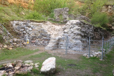
After a short while you will see the ruins of an old Victorian building that used to haul coaches up the steep tramway below.
When you are done here, continue along the path with views to the left and start your descent.
Take your time here as this section is VERY steep and can be a little slippery.
Stout shoes and walking poles are recommended.
After a short while you will see the ruins of an old Victorian building that used to haul coaches up the steep tramway below.
 Continue forward following a ground level concrete footpath sign. The wide footpath dips along a ridge with steep wooded slopes on either side.
 Towards the bottom of the hill go straight on if you are parked in the layby or left if you are parked in the Daisybank car park.
It is a shame that this fine walk has to come to an end.
Towards the bottom of the hill go straight on if you are parked in the layby or left if you are parked in the Daisybank car park.
It is a shame that this fine walk has to come to an end.
Updated September 2025